200 Dean Street
Top insights
- Built before 1939 (city records: 1853) — likely subject to NYC lead-paint rules
About this building
City records list 1853 as the year built — the oldest of the 57 buildings we cover in ZIP 11217. Inside the Boerum Hill Historic District.
Comparisons with neighboring buildings, as of October 14, 2026.
12 months to May 2026
rent-stabilized with
DHCR (most recent year)
units (PLUTO)
rent
min walk
(311 complaints)
errands grade
nearby
200 Dean Street
Open in Google Street View ↗
200 Dean Street sits in Brooklyn, ZIP 11217. The closest subway is Hoyt-Schermerhorn Sts (A,C,G) (4-minute walk), served by the 2, 3, 4, 5, A, B, C, D, F, G, N, Q, and R lines.
Building Condition
No HPD lead-paint violations are on record for this building. That means no complaint or inspection was filed — not that the building is lead-free.
Built 1853. Under NYC Local Law 1 (Admin Code §27-2056.5), lead paint is presumed present in common areas and in apartments where a child under 6 resides, in multiple dwellings built before 1960. The presumption stands unless the owner obtained a lead-free or lead-safe exemption from HPD. Those exemption records aren’t published as open data, so we can’t confirm one either way.
The Building
Neighborhood & Environment
~1 block 300m
~2-3 blocks
- PETIT LARCENY: 12
- HARRASSMENT 2: 11
- DANGEROUS DRUGS: 10
- ASSAULT 3 & RELATED OFFENSES: 6
- GRAND LARCENY: 4
- Illegal Parking: 324
- Blocked Driveway: 43
- Sidewalk Condition: 29
- Street Condition: 22
- Missed Collection: 20
- 435 PACIFIC ST
- 175 WYCKOFF ST
- 80 BOND ST
- P.S. 038 The Pacific
- P.S. K369 - Coy L. Cox School
- P.S. 261 Philip Livingston
- P.S. K369 - Coy L. Cox School
- The Math & Science Exploratory School
- Success Academy Charter School - Cobble Hill
- P.S. K369 - Coy L. Cox School
- Cobble Hill School of American Studies
- Brooklyn High School of the Arts
- Hoyt-Schermerhorn Sts
- Bergen St
- Nevins St
- Grade A
- Grade A
- Grade A
- Grade A
- Grade A
- Grade A
- Grade A
- Grade A
- Sixteen Sycamores Playground
- P.s. 038 The Pacific
- Sterling School
- Medical Aid Training Schools Inc
- Fox Square Plaza
- Boerum Park
Internet providers serving this area
Internet providers available in this area — including fiber:
- Verizon Fiber Up to 2,300 Mbps down · 2,300 Mbps up
- Spectrum Cable Up to 1,000 Mbps down · 35 Mbps up
How to check internet providers before signing an NYC lease →
Source: FCC Broadband Data Collection (NY, rev. May 2026). Wired broadband only — cable + fiber. DSL, satellite, and fixed-wireless not included. Block-level data; actual availability may vary by building.
Market & Availability
Latest news from Weverit.
Tenant guides, law changes, and neighborhood reports — written in plain English, sourced from the same public records that power Weverit building reports.
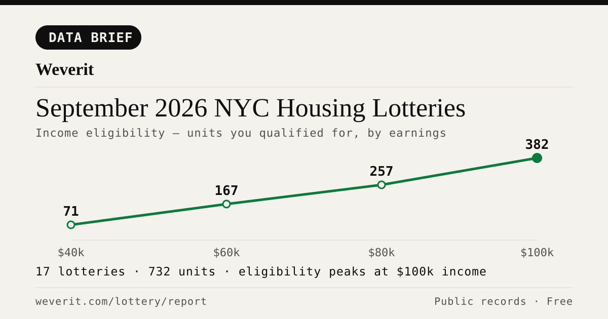
September 2026 NYC Housing Lotteries: Who Qualifies
28 lotteries, 965 affordable units — who qualifies by income, plus rents, AMI bands and application windows, from public records.
Read article →
Your Housing Connect Log Number Came Up. Here's What to Check Before You Sign.
A Housing Connect listing tells you the rent and the apartment size. It does not tell you how the building is run. Seven public records to check before you sign — and what a clean record does not mean.
Read article →
NYC's Smallest Apartment Buildings Have Four Times More Dangerous Violations Per Apartment Than Its Largest
We measured open HPD violations per apartment across NYC buildings. Buildings with six units or fewer carry four times the immediately-hazardous violations per apartment that buildings of 38+ units do — and they are the least likely to draw attention.
Read article →
Pets in your NYC apartment: the no-pet clause, the waiver rule, and what your landlord can actually enforce
NYC's Pet Law gives tenants who openly keep a pet for 3 months legal protection against no-pet clauses. Here's exactly how it works.
Read article →
How to find out who owns your NYC apartment building
Most NYC buildings are owned through LLCs. Here's how to trace the owner through ACRIS, HPD registration, and DOF records — step by step.
Read article →
How to check a NYC building's complaint history — and what it actually means
Complaints and violations are not the same thing. Here's how to read HPD and DOB records — and what the patterns actually tell you about a building.
Read article →
Certificate of Occupancy in NYC: what it is and why it matters before you sign
A C of O defines how a building can legally be used and how many units are permitted. Here's what to check — and what missing or mismatched records mean for tenants.
Read article →Recent building reports from Weverit.
The most recently generated reports from real NYC addresses — independent due-diligence on buildings tenants are actually checking.
782 Amsterdam Avenue
Free public-records report for 782 Amsterdam Avenue: violations, complaints, rent stabilization, transit, schools.
Read report →20 Snyder Avenue
Free public-records report for 20 Snyder Avenue: violations, complaints, rent stabilization, transit, schools.
Read report →140-35 Burden Crescent
Free public-records report for 140-35 Burden Crescent: violations, complaints, rent stabilization, transit, schools.
Read report →400 Hunter Avenue
Free public-records report for 400 Hunter Avenue: violations, complaints, rent stabilization, transit, schools.
Read report →164 East 90th Street
Free public-records report for 164 East 90th Street: violations, complaints, rent stabilization, transit, schools.
Read report →984 Ogden Avenue
Free public-records report for 984 Ogden Avenue: violations, complaints, rent stabilization, transit, schools.
Read report →Check another building
Pull the same public-records report for any NYC address — free, no signup.
Never miss an affordable apartment
Weverit's lottery digest tracks new NYC Housing Connect lotteries and no-lottery re-rentals — one curated email.
Get the lottery digest →