43-18 Newtown Road
Class B
Class C
12 months to Sep 2026
rent-stabilized with
DHCR (most recent year)
12 months through September 2026
rent
min walk
(311 complaints)
errands grade
nearby
Top insights
- No open HPD violations — cleaner than 59% of buildings in this ZIP
- Fewer HPD complaints than the neighborhood average (0 vs ~4)
43-18 Newtown Road
Open in Google Street View ↗
- City records show no open HPD violations here — ask what was most recently repaired and how maintenance requests are handled, since a clean record isn’t a guarantee of upkeep.
- We found no DHCR rent-stabilization unit count for this building. That is not the same as the building being market-rate — a registration can be on file with no unit figure, or not have been filed at all. Ask the landlord directly whether the unit is rent-stabilized, and request your own rent history from DHCR.
43-18 Newtown Road sits in Queens, ZIP 11103. The closest subway is 46 St (M,R) (4-minute walk), served by the M and R lines.
Building Condition
No HPD lead-paint violations are on record for this building — no complaint or inspection was filed, which is not the same as the building being lead-free. Under NYC Local Law 1 (§27-2056.5), lead paint is presumed in multiple dwellings built before 1960; this building’s construction year isn’t available to say whether that presumption applies.
The Building
Neighborhood & Environment
~1 block 300m
~2-3 blocks
- PETIT LARCENY: 92
- HARRASSMENT 2: 46
- GRAND LARCENY: 30
- ASSAULT 3 & RELATED OFFENSES: 24
- MISCELLANEOUS PENAL LAW: 19
- Illegal Parking: 108
- Noise - Residential: 87
- Snow or Ice: 31
- Blocked Driveway: 23
- Traffic Signal Condition: 21
- 4408 31ST AVE
- 3098 43 STREET
- 3090 43 STREET
- P.S. 070
- P.S. 151 Mary D. Carter
- Our World Neighborhood Charter School
- I.S. 010 Horace Greeley
- Our World Neighborhood Charter School
- William Cullen Bryant High School
- Frank Sinatra School of the Arts High School
- 46 St
- Steinway St
- Grade A
- Grade A
- Grade A
- Grade A
- Grade A
- Grade A
- Grade A
- Grade A
- Ayazamana Cultural Center
- Corporal Frank F. Fagan Sq.
- Woodside
- Betty Owen Secretarial Systems
- Astoria Heights Playground
- P.s. 070
Internet providers serving this area
Internet providers available in this area — including fiber:
- Verizon Fiber Up to 2,300 Mbps down · 2,300 Mbps up
- Astound Broadband Cable Up to 1,500 Mbps down · 50 Mbps up
- Spectrum Cable Fiber Up to 1,000 Mbps down · 1,000 Mbps up
How to check internet providers before signing an NYC lease →
Source: FCC Broadband Data Collection (NY, rev. May 2026). Wired broadband only — cable + fiber. DSL, satellite, and fixed-wireless not included. Block-level data; actual availability may vary by building.
Market & Availability
Latest news from Weverit.
Tenant guides, law changes, and neighborhood reports — written in plain English, sourced from the same public records that power Weverit building reports.
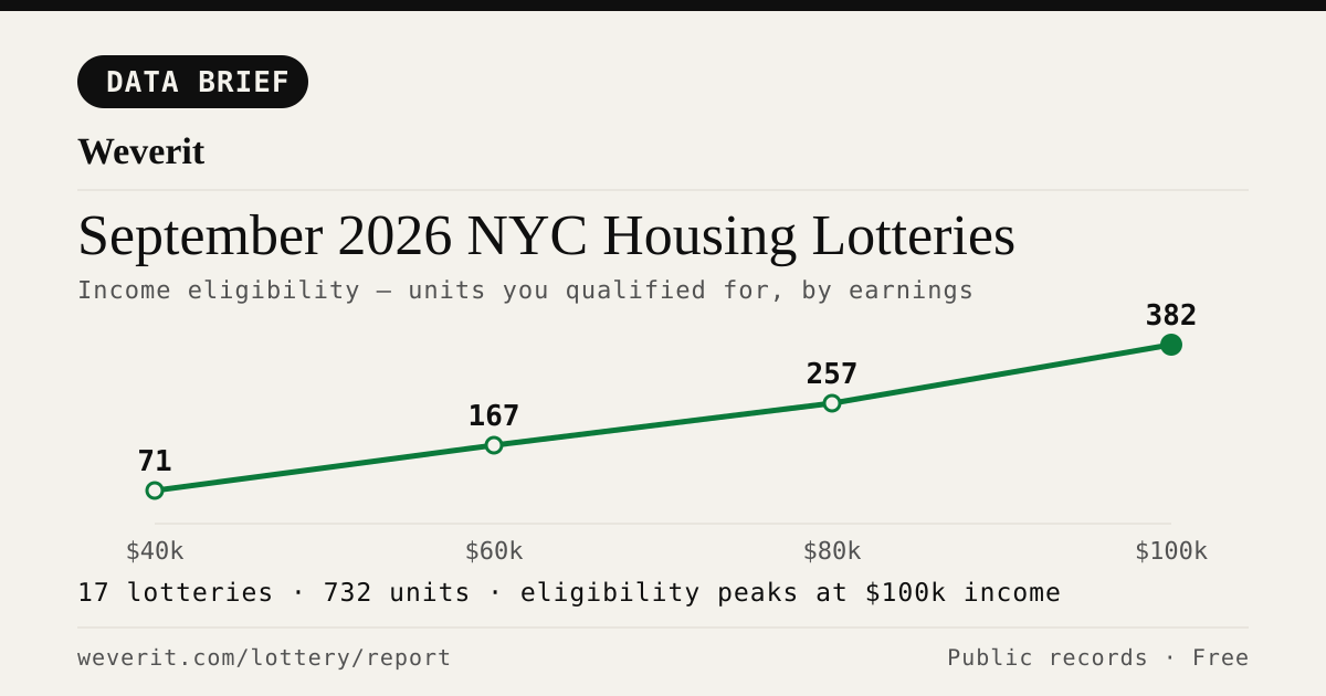
September 2026 NYC Housing Lotteries: Who Qualifies
28 lotteries, 965 affordable units — who qualifies by income, plus rents, AMI bands and application windows, from public records.
Read article →
NYC Housing Connect Login Problems: Recover Your Account
Locked out of NYC Housing Connect? Learn how to reset your password, recover your email access, avoid duplicate applications, and contact HPD.
Read article →
Your Housing Connect Log Number Came Up. Here's What to Check Before You Sign.
A Housing Connect listing tells you the rent and the apartment size. It does not tell you how the building is run. Seven public records to check before you sign — and what a clean record does not mean.
Read article →
NYC's Smallest Apartment Buildings Have Four Times More Dangerous Violations Per Apartment Than Its Largest
We measured open HPD violations per apartment across NYC buildings. Buildings with six units or fewer carry four times the immediately-hazardous violations per apartment that buildings of 38+ units do — and they are the least likely to draw attention.
Read article →
Pets in your NYC apartment: the no-pet clause, the three-month rule, and what your landlord can actually enforce
NYC's three-month pet rule may protect tenants in some buildings. Learn about landlord notice, court deadlines, exceptions, and how to document your case.
Read article →
How to find out who owns your NYC apartment building
Most NYC buildings are owned through LLCs. Here's how to trace the owner through ACRIS, HPD registration, and DOF records — step by step.
Read article →
How to check a NYC building's complaint history — and what it actually means
Complaints and violations are not the same thing. Here's how to read HPD and DOB records — and what the patterns actually tell you about a building.
Read article →Recent building reports from Weverit.
The most recently generated reports from real NYC addresses — independent due-diligence on buildings tenants are actually checking.
187 Stanhope Street
Free public-records report for 187 Stanhope Street: violations, complaints, rent stabilization, transit, schools.
Read report →78 Prospect Park West
Free public-records report for 78 Prospect Park West: violations, complaints, rent stabilization, transit, schools.
Read report →1552 Greene Avenue
Free public-records report for 1552 Greene Avenue: violations, complaints, rent stabilization, transit, schools.
Read report →4611 6th Avenue
Free public-records report for 4611 6th Avenue: violations, complaints, rent stabilization, transit, schools.
Read report →151 West 95th Street
Free public-records report for 151 West 95th Street: violations, complaints, rent stabilization, transit, schools.
Read report →106 West 105th Street
Free public-records report for 106 West 105th Street: violations, complaints, rent stabilization, transit, schools.
Read report →Check another building
Pull the same public-records report for any NYC address — free, no signup.
Never miss an affordable apartment
Weverit's lottery digest tracks new NYC Housing Connect lotteries and no-lottery re-rentals — one curated email.
Get the lottery digest →