WeveritNYC Building Reports
Building report · Brooklyn 11212 Independent · Tenant-side · No broker affiliations
Building report

60 Glenmore Avenue

Brooklyn · 11212 | BBL 3034890001 | BIN 3348343
HPD data as of November 3, 2026
Grade withheld: no HPD registration for a building that requires one

This building has 96 apartments on record, and a building with three or more apartments is required to be registered with HPD. The city has no registration for this address, so the absence of violation records here is not evidence of a clean record — the records may be kept under another address or another building ID. We withhold the compliance grade rather than publish a clean verdict we cannot stand behind. The other public-records sections below are this building’s own and are unaffected.

Look up this building on HPD Online ↗

Open Buildings Department records

City Buildings Department (DOB) records show 13 open DOB violations at this address, none in the immediately dangerous class. See the DOB Compliance section below.

345
311 calls
12 months to Jul 2026
n/a
Units registered as
rent-stabilized with
DHCR (most recent year)
815
Total residential
units (PLUTO)
275
Crime incidents (150m)
12 months through June 2026
$1,231
ZIP median
rent
1954
Year built
7 min
Closest subway
min walk
D
Noise grade
(311 complaints)
A
Walkable
errands grade
21 places
Amenities
nearby

Top insights

About this building

City records list 1954 as the year built — newer than 78% of the 474 buildings we cover in ZIP 11212. 815 apartments — more than 99% of the 462 residential buildings we cover in ZIP 11212 have.

Comparisons with neighboring buildings, as of November 7, 2026.

60 Glenmore Avenue sits in Brooklyn, ZIP 11212. The closest subway is Sutter Av (L) (7-minute walk), served by the L line.

What's the closest subway to 74 Watkins Street?
Sutter Av (L) — a 7-minute walk (593m) from 60 Glenmore Avenue. Served by the L line.
Is 74 Watkins Street subject to lead-paint regulations?
Yes — built in 1954, before NYC's 1960 lead-paint cutoff. Annual inspections are required for units with children under 6. Source: NYC Local Law 1.

Building Condition

HPD Violations
—
This building only
HPD has no registration record for this address, so no violation history is linked to this building. Registration requirements depend on how a building is owned and occupied. This is not a data outage.
HPD Complaints
This building only
No HPD complaints filed in the past 12 months. No tenant has formally escalated a condition to HPD; could indicate clean upkeep, or that issues are being handled before reaching HPD.
Evictions
This building only
Executed residential evictions — last 5 years
Total1
By year
20241
Most recent
  • 2024-10-23 Apt 05F
DOB Compliance
This building only
All-time DOB activity
Violations
Total13
Open13
Closed0
Complaints
Total10
Open (active)1
Closed9
Recent open violations
  • 2025-06-03 C-CONSTRUCTION OTHER OPTIONAL "FAILURE TO MAINTAIN BUILDING IN CODE COMPLIANT MANNER.AS NOTED AT TIME OF INSPECTION,OBSERVED ON EXP1,2,3&4 EL…"
  • 2021-12-17 HVCAT5-NYCHA ELEVATOR PERIODIC INSPECTION/TEST ELEVATORREQUI… "FAILURE TO PERFORM CATEGORY 5 INSPECTION"
  • 2019-06-24 FISP-FACADE SAFETY PROGRAM FACADE REQUIRED
DOB data as of July 30, 2026 — DOB records on this page date from the last full report rebuild.
Bedbug History
This building only
HPD annual bedbug report (building-aggregate, no apt-level data)
Risk levelclean ✓
Filings on file0
Infested (last 3 yr)0
Lead Paint Exposure
This building only

No HPD lead-paint violations are on record for this building. That means no complaint or inspection was filed — not that the building is lead-free.

Built 1954. Under NYC Local Law 1 (Admin Code §27-2056.5), lead paint is presumed present in common areas and in apartments where a child under 6 resides, in multiple dwellings built before 1960. The presumption stands unless the owner obtained a lead-free or lead-safe exemption from HPD. Those exemption records aren’t published as open data, so we can’t confirm one either way.

Source: HPD lead-paint violations (NYC Admin Code §27-2056).

The Building

Building (PLUTO)
Lot-level data — describes the whole tax lot (3 buildings on it), not this building alone.
NYC PLUTO tax-lot data
Year built1954 (72 yr old)
Building classD3 — Elevator apartment
Floors7
Residential units815
Building area (sqft)771,366
Lot area (sqft)658,440
Owner of record (PLUTO)NYC HOUSING AUTHORITY
Designations
Council district41
Rent Stabilization
—
Lot-level data — describes the whole tax lot (3 buildings on it), not this building alone.
BBL not found in the Who Owns What database — typically a small portfolio outside that dataset's coverage, or a recently created tax lot. Rent-stabilization status cannot be confirmed here without a DHCR records request. (As of July 30, 2026.)
Energy Efficiency (LL84)
Energy benchmarking (Local Law 84) — 2024
Energy efficiency gradeD
ENERGY STAR score11 / 100
Site EUI136.2 kBtu/ft² (national median 100.8)
Recent years
2024Grade D · 11/100
2023Grade D · 35/100
2022Grade D · 49/100

Neighborhood & Environment

Crime
NYPD complaints · 12 months through June 2026
150m
~1 block
300m
~2-3 blocks
Total2751,236
Violent26121
Shooting victims (Jan–Dec 2024)45
Felonies98426
Misdemeanors126549
Violations38204
Shooting counts are victim records — one incident with several victims counts more than once — and reflect Jan–Dec 2024 — most recent NYC shooting data available. All other counts cover 12 months through June 2026 — the most recent 12 months of available NYPD data.
Top crime types (300m radius):
  • HARRASSMENT 2: 196
  • ASSAULT 3 & RELATED OFFENSES: 166
  • PETIT LARCENY: 131
  • DANGEROUS DRUGS: 128
  • CRIMINAL MISCHIEF & RELATED OF: 92
Borough context: Brooklyn (12 mo): 79,674 incidents total.
311 / Quality of Life
Last 12 months · 150m radius
Total 311 calls345
Top complaint types
  • Noise - Street/Sidewalk: 40
  • Illegal Parking: 39
  • HEAT/HOT WATER: 31
  • Noise - Residential: 30
  • UNSANITARY CONDITION: 17
By category
Other225
Noise75
Parking40
Homeless2
Construction2
Rats1
Drug0
Trash0
Drinking0
311 data as of July 30, 2026 — 311 records on this page date from the last full report rebuild.
Noise (311 dedicated)
D
Last 12 months · 150m radius
Total noise complaints75
Dominant subtypeStreet Sidewalk
By subtype
Street Sidewalk40
Residential30
Commercial4
Vehicle1
Noise-grade thresholds (per 12 months): A <10 · B <20 · C <50 · D <100
Noise grade: D — High noise activity. Based on 311 noise complaints logged within 150m over 12 months — an area signal, not a characteristic of this building. Separate from the building's compliance grade.
Flood Risk
Flood hazard zone — NYC 2020s floodplain projection (FEMA-based)
Zone X — minimal flood hazard (outside the mapped floodplain)
Flood susceptibility3 / 5
Parking
800m walk radius · NYC business-license records
Garages nearby5
Estimated monthly$250–400/mo
Closest 3 garages
  • 1759 PITKIN AVE 105m · $250–400/mo licensee: SAMUEL, PETER
  • 1735 PITKIN AVE 119m · $250–400/mo licensee: KING TOBACCO & GROCERY CORP
  • 1736 PITKIN AVE 121m · $250–400/mo licensee: MODELL COLLATERAL LOANS INC.
Schools
Schools within 1 km / ~0.6 mile walk
Total nearby26
Elementary (K-5)8
Middle (6-8)6
High (9-12)4
Elementary — closest 3 by walk (8)
  • P.S. 298 Dr. Betty Shabazz K-5 · 1 min (83m) · District 23
  • P.S. 332 Charles H. Houston Pre-K-8 · 3 min (266m) · District 23
  • Christopher Avenue Community School Pre-K-5 · 3 min (266m) · District 23
Middle — closest 3 by walk (6)
  • Brownsville Collaborative Middle School 6-8 · 1 min (83m) · District 23
  • P.S. 332 Charles H. Houston Pre-K-8 · 3 min (266m) · District 23
  • P.S. K396 1-12 · 5 min (399m) · District 75
High — closest 3 by walk (4)
  • P.S. K396 1-12 · 5 min (399m) · District 75
  • Achievement First Brownsville Charter School K-12 · 6 min (515m) · District 84
  • Brooklyn Collegiate: A College Board School 9-12 · 6 min (515m) · District 23
Data source: NYC DOE school locations.
Subway / Transit
800m walk radius
Stations nearby2
Unique lines1
Lines served: L
Closest 2 stations
  • Sutter Av L · 593m · 7 min walk
  • Atlantic Av L · 680m · 8 min walk
Neighborhood Amenities
A
800m walk radius
Total places nearby21
Eating (7) restaurants + fast food
Restaurants1
Fast food6
Daily essentials
Grocery (incl. convenience)12
→ Supermarkets1
→ Convenience11
Pharmacies1
ATMs0
ⓘ OpenStreetMap has no ATMs mapped within 800 m of this address. These counts come from volunteer mapping, so a zero means nothing of that kind is on the map here — not that there is none.
Coffee Index C — Some coffee nearby (2 places selling coffee, of which 1 tagged as a café).
Walkable Errands A — Excellent walkability — all errand types nearby.
Restaurants Nearby
DOH-graded restaurants within ~450 m of this building
Graded restaurants nearby33
A: 26 B: 2 C: 1 Pending: 4
Sample
  • Grade A Dennis' Place · American
  • Grade A Pitkin Caribbean Bakery · Caribbean
  • Grade A Dunkin', Baskin Robbins · American
  • Grade A Shun Fat Kitchen · Chinese
  • Grade A Sal & Paul's Pizzeria · Pizza
  • Grade A Pitkin Seafood · Seafood
  • Grade A Big Apple Kitchen · Chinese
  • Grade A 401 Lucky Star Restaurant · Chinese
Civic Facilities Nearby
Civic facilities within ~450 m of this building
Facilities nearby123
By category — top 8 of 17 (107 of 123 facilities)
Youth Services28
Human Services18
Parks And Plazas12
Schools (K-12)11
Child Services And Welfare11
Day Care And Pre-Kindergarten11
Health Care9
Solid Waste7
Sample (parks · schools · cultural)
  • Powell Playground Parks And Plazas
  • Carter G. Woodson Children's Park Parks And Plazas
  • Parking For Crossroads City Agency Parking, Maintenance, And Storage
  • P.s. 150 Christopher Schools (K-12)
  • Brownsville Library Libraries
  • Uncommon Brownsville South Cms Schools (K-12)

Internet providers serving this area

Internet providers available in this area — including fiber:

  • Optimum Cable Fiber Up to 8,000 Mbps down · 8,000 Mbps up
  • Verizon Fiber Up to 980 Mbps down · 880 Mbps up

How to check internet providers before signing an NYC lease →

Source: FCC Broadband Data Collection (NY, rev. May 2026). Wired broadband only — cable + fiber. DSL, satellite, and fixed-wireless not included. Block-level data; actual availability may vary by building.

Market & Availability

ZIP Median Rent
ZIP 11212 · ACS 5-Year 2019–2023 · ZIP level
Median rent$1,231/mo
Reflects existing leases, not current asking prices.
Affordability
ZIP 11212 · ACS 5-Year 2019–2023 · ZIP level
Median household income$40,060/yr
Median monthly income$3,338/mo
Max rent (30% rule)$1,001/mo
ZIP median rent$1,231/mo
ZIP median rent is 36.9% of median household income. The 30% threshold is the federal standard for housing cost burden.
Latest news

Latest news from Weverit.

Tenant guides, law changes, and neighborhood reports — written in plain English, sourced from the same public records that power Weverit building reports.
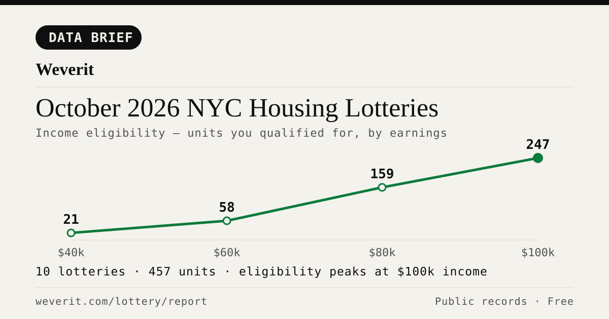
Income-eligibility curve for October 2026 NYC housing lotteries
DATA BRIEF·Nov 1, 2026

October 2026 NYC Housing Lotteries: Who Qualifies

11 lotteries, 477 affordable units — who qualifies by income, plus rents, AMI bands and application windows, from public records.

Read article →
Weverit guide cover: How Long Does NYC Housing Connect Take? From Application to Keys
GUIDE·Oct 28, 2026

How Long Does NYC Housing Connect Take? From Application to Keys

The official guide says interviews come two to ten months after a deadline. A 2026 case study of one Bronx building shows what can happen after that, and why most applicants drop out.

Read article →
Weverit guide cover: Selected in NYC Housing Connect? What Happens Next and the Documents You Need
GUIDE·Oct 28, 2026

Selected in NYC Housing Connect? What Happens Next and the Documents You Need

Your Housing Connect log number came up. Here is what the eligibility review looks like, which documents to gather, and the response deadlines that knock out most applicants.

Read article →
Weverit guide cover: NYC Housing Connect Login Problems: Recover Your Account
GUIDE·Oct 15, 2026

NYC Housing Connect Login Problems: Recover Your Account

Locked out of NYC Housing Connect? Learn how to reset your password, recover your email access, avoid duplicate applications, and contact HPD.

Read article →
Times Square in Manhattan, with digital billboards above the street and people looking up at the towers
HOUSING LOTTERY·Sep 27, 2026

Your Housing Connect Log Number Came Up. Here's What to Check Before You Sign.

A Housing Connect listing tells you the rent and the apartment size. It does not tell you how the building is run. Seven public records to check before you sign — and what a clean record does not mean.

Read article →
New york
MARKET-BRIEF·Sep 19, 2026

NYC's Smallest Apartment Buildings Have Four Times More Dangerous Violations Per Apartment Than Its Largest

We measured open HPD violations per apartment across NYC buildings. Buildings with six units or fewer carry four times the immediately-hazardous violations per apartment that buildings of 38+ units do — and they are the least likely to draw attention.

Read article →
Corner apartment building with fire escapes above storefront awnings and sidewalk seating
TENANT GUIDE·Sep 6, 2026

Pets in your NYC apartment: the no-pet clause, the three-month rule, and what your landlord can actually enforce

NYC's three-month pet rule may protect tenants in some buildings. Learn about landlord notice, court deadlines, exceptions, and how to document your case.

Read article →

Check another building

Pull the same public-records report for any NYC address — free, no signup.

Never miss an affordable apartment

Weverit's lottery digest tracks new NYC Housing Connect lotteries and no-lottery re-rentals — one curated email.

Get the lottery digest →
Report built July 30, 2026 · Click ↻ to refresh data · Public records: NYC Open Data, MTA, JustFix WoW; neighborhood amenities © OpenStreetMap contributors (ODbL)