41-25 71st Street
Class B
Class C
rent-stabilized with
DHCR (most recent year)
units (PLUTO)
12 months through June 2026
rent
min walk
errands grade
nearby
Top insights
- Fewer HPD complaints than the neighborhood average (0 vs ~4)
- Built in 1985 (city records)
About this building
City records list 1985 as the year built — newer than 92% of the 624 buildings we cover in ZIP 11377.
Comparisons with neighboring buildings, as of October 18, 2026.
A difference between the DHCR rent-stabilized count and the PLUTO total is common and does not, on its own, indicate a violation: units can leave rent stabilization legally, the two datasets count units differently, some units may be non-residential, and a registration can be filed incompletely. To check your own apartment, see how to request your rent history from DHCR.
41-25 71st Street
Open in Google Street View ↗
- City records show 6 open HPD violations at this building. Ask which are still unresolved in the unit and the landlord’s timeline to clear them.
- The oldest open violation on record dates to 2021 — why has it stayed open this long, and is it in or near this unit?
- DHCR’s most recent registration lists no rent-stabilized units in this building. If anyone tells you this unit is stabilized, ask to see the registration — and if it was deregulated, ask on what grounds and in what year.
- Confirm the condition behind the most recent open violation was actually repaired, not just marked closed: File annual bedbug report in accordance with hpd rule as described on the back of this….
41-25 71st Street sits in Queens, ZIP 11377. The closest subway is 69 St (7) (4-minute walk), served by the 7 line.
Building Condition
Oldest open violation: April 2021 · Most recent: May 2026. HPD marks a violation open until it is certified as corrected, so an old date can mean an unresolved condition or a repair that was never certified.
- 2026-05-06
- 2025-06-11
- 2024-04-15
- 2023-03-28
- 2022-03-03
- Class A · 6 open · penalty 6 · (1/ea)
- 2025-11-14 "VIOLATION ISSUED-FAILURE TO FILE 2024 EXTERNAL LOW PRESSURE INSPECTION"
- 2023-04-25 "VIOLATION ISSUED-FAILURE TO FILE 2022 EXTERNAL LOW PRESSURE INSPECTION"
- 2014-05-15 "VIOLATION ISSUED FOR FAILURE TO FILE ANNUAL BOILER 2012 INSPECTION REPORT"
No HPD lead-paint violations on record. Built 1985, after the 1978 federal ban on lead paint in residential use. Owners must still address any lead hazard that is later identified.
The Building
Neighborhood & Environment
~1 block 300m
~2-3 blocks
- HARRASSMENT 2: 41
- PETIT LARCENY: 37
- ASSAULT 3 & RELATED OFFENSES: 36
- GRAND LARCENY: 29
- PROSTITUTION & RELATED OFFENSES: 22
- 6907 WOODSIDE AVE
- 6904 WOODSIDE AVE
- 4023 73RD ST
- P.S. 012 James B. Colgate
- P.S. 069 Jackson Heights
- The 51 Avenue Academy (The Path To Academic Excell
- I.S. 5 - The Walter Crowley Intermediate School
- Renaissance Charter School
- I.S. 230
- Renaissance Charter School
Levels add up to 9 because a school serving K-8 is listed under both Elementary and Middle. 7 distinct schools are within range.
- 69 St
- Jackson Hts-Roosevelt Av/74 St-Broadway
- 65 St
- Grade A
- Grade A
- Grade A
- Grade A
- Grade A
- Grade A
- Grade A
- Grade A
- Diversity Plaza
- Spargo Park
- P.s. 012 James B. Colgate
- Jackson Heights Sda School
- Park
- Latham Park
Internet providers serving this area
Internet providers available in this area — including fiber:
- Verizon Fiber Up to 2,300 Mbps down · 2,300 Mbps up
- Astound Broadband Cable Up to 1,500 Mbps down · 50 Mbps up
- Spectrum Cable Up to 1,000 Mbps down · 1,000 Mbps up
How to check internet providers before signing an NYC lease →
Source: FCC Broadband Data Collection (NY, rev. May 2026). Wired broadband only — cable + fiber. DSL, satellite, and fixed-wireless not included. Block-level data; actual availability may vary by building.
Market & Availability
Latest news from Weverit.
Tenant guides, law changes, and neighborhood reports — written in plain English, sourced from the same public records that power Weverit building reports.
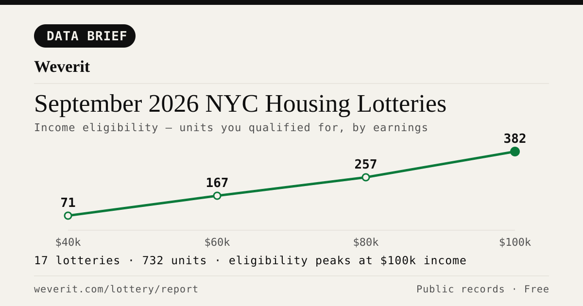
September 2026 NYC Housing Lotteries: Who Qualifies
28 lotteries, 965 affordable units — who qualifies by income, plus rents, AMI bands and application windows, from public records.
Read article →
NYC Housing Connect Login Problems: Recover Your Account
Locked out of NYC Housing Connect? Learn how to reset your password, recover your email access, avoid duplicate applications, and contact HPD.
Read article →
Your Housing Connect Log Number Came Up. Here's What to Check Before You Sign.
A Housing Connect listing tells you the rent and the apartment size. It does not tell you how the building is run. Seven public records to check before you sign — and what a clean record does not mean.
Read article →
NYC's Smallest Apartment Buildings Have Four Times More Dangerous Violations Per Apartment Than Its Largest
We measured open HPD violations per apartment across NYC buildings. Buildings with six units or fewer carry four times the immediately-hazardous violations per apartment that buildings of 38+ units do — and they are the least likely to draw attention.
Read article →
Pets in your NYC apartment: the no-pet clause, the three-month rule, and what your landlord can actually enforce
NYC's three-month pet rule may protect tenants in some buildings. Learn about landlord notice, court deadlines, exceptions, and how to document your case.
Read article →
How to find out who owns your NYC apartment building
Most NYC buildings are owned through LLCs. Here's how to trace the owner through ACRIS, HPD registration, and DOF records — step by step.
Read article →
How to check a NYC building's complaint history — and what it actually means
Complaints and violations are not the same thing. Here's how to read HPD and DOB records — and what the patterns actually tell you about a building.
Read article →Recent building reports from Weverit.
The most recently generated reports from real NYC addresses — independent due-diligence on buildings tenants are actually checking.
463 40th Street
Free public-records report for 463 40th Street: violations, complaints, rent stabilization, transit, schools.
Read report →400 Central Park West
Free public-records report for 400 Central Park West: violations, complaints, rent stabilization, transit, schools.
Read report →1 East 35th Street
Free public-records report for 1 East 35th Street: violations, complaints, rent stabilization, transit, schools.
Read report →136 Jefferson Street
Free public-records report for 136 Jefferson Street: violations, complaints, rent stabilization, transit, schools.
Read report →6791 223rd Place Bayside 11364
Free public-records report for 6791 223rd Place Bayside 11364: violations, complaints, rent stabilization, transit, schools.
Read report →1444 Schenectady Avenue
Free public-records report for 1444 Schenectady Avenue: violations, complaints, rent stabilization, transit, schools.
Read report →Check another building
Pull the same public-records report for any NYC address — free, no signup.
Never miss an affordable apartment
Weverit's lottery digest tracks new NYC Housing Connect lotteries and no-lottery re-rentals — one curated email.
Get the lottery digest →