WeveritNYC Building Reports
Building report · Manhattan 10023 Independent · Tenant-side · No broker affiliations
Building report

101 West 67th Street

Manhattan · 10023 | BBL 1011397503 | BIN 1084564
HPD data as of November 5, 2026
A
Compliance verdict — Clean record — no open violations

HPD’s records show no open housing-code violations for this building as of Nov 5, 2026.

Filed by HPD under 1992 Broadway — the city’s address directory lists that address and this one as the same building (BIN 1084564).

A 271-unit building, built in 1992.

Building identification — the city files this building’s records under 1992 BROADWAY. It is the same building, and the records below are its own.
Open Buildings Department records

City Buildings Department (DOB) records show 32 open DOB violations at this address, none in the immediately dangerous class. See the DOB Compliance section below.

0
Open HPD
Class B
0
Open HPD
Class C
1419
311 calls
12 months to Sep 2026
—
Units registered as
rent-stabilized with
DHCR (most recent year)
271
Total residential
units (PLUTO)
158
Crime incidents (150m)
12 months through June 2026
$3,050
ZIP median
rent
1992
Year built
2 min
Closest subway
min walk
D
Noise grade
(311 complaints)
A
Walkable
errands grade
196 places
Amenities
nearby

Top insights

About this building

The building’s floor space is 12.7 times the size of its lot: 706,837 sq ft of building on a 55,462 sq ft lot.

Comparisons with neighboring buildings, as of November 9, 2026.

101 West 67th Street sits in Manhattan, ZIP 10023. The closest subway is 66 St-Lincoln Center (1) (2-minute walk), served by the 1 line.

What's the closest subway to 101 West 67th Street?
66 St-Lincoln Center (1) — a 2-minute walk (133m) from 101 West 67th Street. Served by the 1 line.

Building Condition

HPD Violations
All-time HPD violations
Total2
Open0
Closed2
ⓘ Counted under 1992 Broadway, which the city lists as this same building. HPD files violations by street address, and this building is on file under that address rather than the one on this page — common for a corner building recorded on its cross street. The city’s address directory gives both the same building identification number (BIN 1084564), so these are this building’s records.
By severity class
Class A0 open · 1 closed
Class I0 open · 1 closed
Pest Activity — part of HPD violations
No open pest violations on record.
Source: NYC Open Data, HPD open violations, as of November 5, 2026.
HPD Complaints
No HPD complaints filed in the past 12 months. No tenant has formally escalated a condition to HPD; could indicate clean upkeep, or that issues are being handled before reaching HPD.
Evictions
Executed residential evictions — last 5 years
Total1
By year
20221
Most recent
  • 2022-11-02 Apt 55-PH2B
DOB Compliance
DOB BIS ↗
All-time DOB activity
Violations
Total200
Open32
Closed168
Complaints
Total86
Open (active)0
Closed86
Recent open violations
  • 2021-12-17 EVCAT5-NON-RESIDENTIAL ELEVATOR PERIODIC INSPECTION/TEST ELE… "FAILURE TO PERFORM CATEGORY 5 INSPECTION"
  • 2020-06-15 E-ELEVATOR ELEVATORREQUIRED
  • 2019-09-06 ACC1-(OTHER BLDGS TYPES) - ELEVATOR AFFIRMATION OF CORRECTIO… "VIO ISSUED TO ELEVATOR - FAIL TO CORRECT DEFECTS ON 2017 CAT 1 INSP/TST TST"
DOB data as of November 5, 2026 — last checked against the Department of Buildings on that date; the records were unchanged.
Bedbug History
HPD annual bedbug report (building-aggregate, no apt-level data)
Risk levellow
Filings on file8
Infested (last 3 yr)1
Yearly trend (last 5)
20251 infested · 1 eradicated
20240 infested · 0 eradicated
20230 infested · 0 eradicated
20220 infested · 0 eradicated
20200 infested · 0 eradicated
Lead Paint Exposure

No HPD lead-paint violations on record. Built 1992, after the 1978 federal ban on lead paint in residential use. Owners must still address any lead hazard that is later identified.

Source: HPD lead-paint violations (NYC Admin Code §27-2056).

The Building

Building (PLUTO)
NYC PLUTO tax-lot data
Year built1992 (34 yr old)
Building classRM — Condo
Floors47
Residential units271
Total units279
Building area (sqft)706,837
Lot area (sqft)55,462
Owner of record (PLUTO)UNAVAILABLE OWNER
Designations
Council district6
ⓘ "UNAVAILABLE OWNER" is the PLUTO sentinel for unregistered or redacted ownership — typically an LLC or recently-changed registration not yet reflected in city records.
Rent Stabilization
DHCR records · NYC HCR via Who Owns What
StatusDHCR unit count unavailable
HPD-registered contact (Who Owns What): Owner on record.
ⓘ Email rent-info@nyshcr.org with your full address and apartment number for a free DHCR rent history.
Energy Efficiency (LL84)
Energy benchmarking (Local Law 84) — 2023
Energy efficiency gradeNot scored
Site EUI—
Recent years
2023Not scored
2022Grade D · 1/100

Neighborhood & Environment

Crime
NYPD complaints · 12 months through June 2026
150m
~1 block
300m
~2-3 blocks
Total158468
Violent921
Shooting victims (Jan–Dec 2024)01
Felonies49174
Misdemeanors91209
Violations1468
Shooting counts are victim records — one incident with several victims counts more than once — and reflect Jan–Dec 2024 — most recent NYC shooting data available. All other counts cover 12 months through June 2026 — the most recent 12 months of available NYPD data.
Top crime types (300m radius):
  • PETIT LARCENY: 154
  • GRAND LARCENY: 114
  • HARRASSMENT 2: 66
  • BURGLARY: 20
  • ASSAULT 3 & RELATED OFFENSES: 18
Borough context: Manhattan (12 mo): 63,344 incidents total.
311 / Quality of Life
Last 12 months · 150m radius
Total 311 calls1,419
Top complaint types
  • Noise - Helicopter: 399
  • Illegal Parking: 153
  • Homeless Person Assistance: 123
  • Noise: 110
  • Vendor Enforcement: 63
By category
Other1,063
Parking176
Homeless123
Noise51
Rats3
Trash1
Drinking1
Construction1
Drug0
311 data as of September 27, 2026 — 311 records on this page date from the last full report rebuild.
Noise (311 dedicated)
D
Last 12 months · 150m radius
Total noise complaints51
Dominant subtypeResidential
By subtype
Residential22
Street Sidewalk21
Commercial5
Vehicle3
Noise-grade thresholds (per 12 months): A <10 · B <20 · C <50 · D <100
Noise grade: D — High noise activity. Based on 311 noise complaints logged within 150m over 12 months — an area signal, not a characteristic of this building. Separate from the building's compliance grade.
Flood Risk
Flood hazard zone — NYC 2020s floodplain projection (FEMA-based)
Zone X — minimal flood hazard (outside the mapped floodplain)
Flood susceptibility1 / 5
Parking
800m walk radius · NYC business-license records
Garages nearby5
Estimated monthly$400–600/mo
Closest 3 garages
  • 111 WEST 68 STREET 71m · $400–600/mo licensee: LINCOLN BUSINESS MACHINES INC.
  • 111 W 68TH ST 71m · $400–600/mo licensee: Lincoln Business Machines Inc
  • BROADWAY 76m · $400–600/mo licensee: SEPANSKI, APRIL D
Schools
Schools within 1 km / ~0.6 mile walk
Total nearby24
Elementary (K-5)5
Middle (6-8)6
High (9-12)6
Elementary — closest 3 by walk (5)
  • Special Music School K-12 · 2 min (164m) · District 3
  • P.S. 199 Jessie Isador Straus K-5 · 5 min (436m) · District 3
  • P.S. 452 K-5 · 8 min (607m) · District 3
Middle — closest 3 by walk (6)
  • Special Music School K-12 · 2 min (164m) · District 3
  • West End Secondary School 6-12 · 8 min (623m) · District 3
  • J.H.S. M044 William J. O'Shea 5-8 · 9 min (747m) · District 3
High — closest 3 by walk (6)
  • Special Music School K-12 · 2 min (164m) · District 3
  • Martin Luther King Hs 9-12 · 4 min (291m) · District 3
  • Manhattan Theatre Lab High School 9-12 · 5 min (362m) · District 3
Data source: NYC DOE school locations.
Subway / Transit
800m walk radius
Stations nearby4
Unique lines7
Lines served: 1 · 2 · 3 · A · B · C · D
Closest 3 stations
  • 66 St-Lincoln Center 1 · 133m · 2 min walk · ADA accessible
  • 72 St C, B · 435m · 5 min walk
  • 72 St 1, 2, 3 · 449m · 6 min walk · ADA accessible
Neighborhood Amenities
A
800m walk radius
Total places nearby196
Eating (122) restaurants + fast food
Restaurants89
Fast food33
Daily essentials
Grocery (incl. convenience)23
→ Supermarkets10
→ Convenience13
Pharmacies11
ATMs1
Coffee Index A — Coffee abundance (41 places selling coffee, of which 40 tagged as a café).
Walkable Errands A — Excellent walkability — all errand types nearby.
Restaurants Nearby
DOH-graded restaurants within ~450 m of this building
Graded restaurants nearby120
A: 103 B: 4 C: 1 Pending: 12
Sample
  • Grade A Cafe Fiorello · Italian
  • Grade A Cafe Luxembourg · French
  • Grade A Westside Restaurant · American
  • Grade A Malachy's · Irish
  • Grade A Pomodoro Rosso · Italian
  • Grade A 72nd Eatery · American
  • Grade A Walter Reade Theater · American
  • Grade A The Muffin Cafe · Bakery Products/desserts
Civic Facilities Nearby
Civic facilities within ~450 m of this building
Facilities nearby157
By category — top 8 of 18 (134 of 157 facilities)
Cultural Institutions32
Transportation29
Parks And Plazas19
Schools (K-12)16
Day Care And Pre-Kindergarten13
Child Services And Welfare10
Solid Waste8
Historical Sites7
Sample (parks · schools · cultural)
  • Lyric Chamber Music Society Of New York, Inc. Cultural Institutions
  • School Of American Ballet, Inc. Cultural Institutions
  • American Folk Art Museum Cultural Institutions
  • Metropolitan Opera Guild, Inc. Cultural Institutions
  • Storm Theatre, Inc. Cultural Institutions
  • Parkside School Schools (K-12)

Internet providers serving this area

Internet providers available in this area — including fiber:

  • Verizon Fiber Up to 2,300 Mbps down · 2,300 Mbps up
  • Astound Broadband Cable Fiber Up to 1,500 Mbps down · 1,500 Mbps up
  • Spectrum Cable Up to 1,000 Mbps down · 50 Mbps up

How to check internet providers before signing an NYC lease →

Source: FCC Broadband Data Collection (NY, rev. May 2026). Wired broadband only — cable + fiber. DSL, satellite, and fixed-wireless not included. Block-level data; actual availability may vary by building.

Market & Availability

ZIP Median Rent
ZIP 10023 · ACS 5-Year 2019–2023 · ZIP level
Median rent$3,050/mo
Reflects existing leases, not current asking prices.
Affordability
ZIP 10023 · ACS 5-Year 2019–2023 · ZIP level
Median household income$157,866/yr
Median monthly income$13,156/mo
Max rent (30% rule)$3,947/mo
ZIP median rent$3,050/mo
ZIP median rent is 23.2% of median household income. The 30% threshold is the federal standard for housing cost burden.
Latest news

Latest news from Weverit.

Tenant guides, law changes, and neighborhood reports — written in plain English, sourced from the same public records that power Weverit building reports.
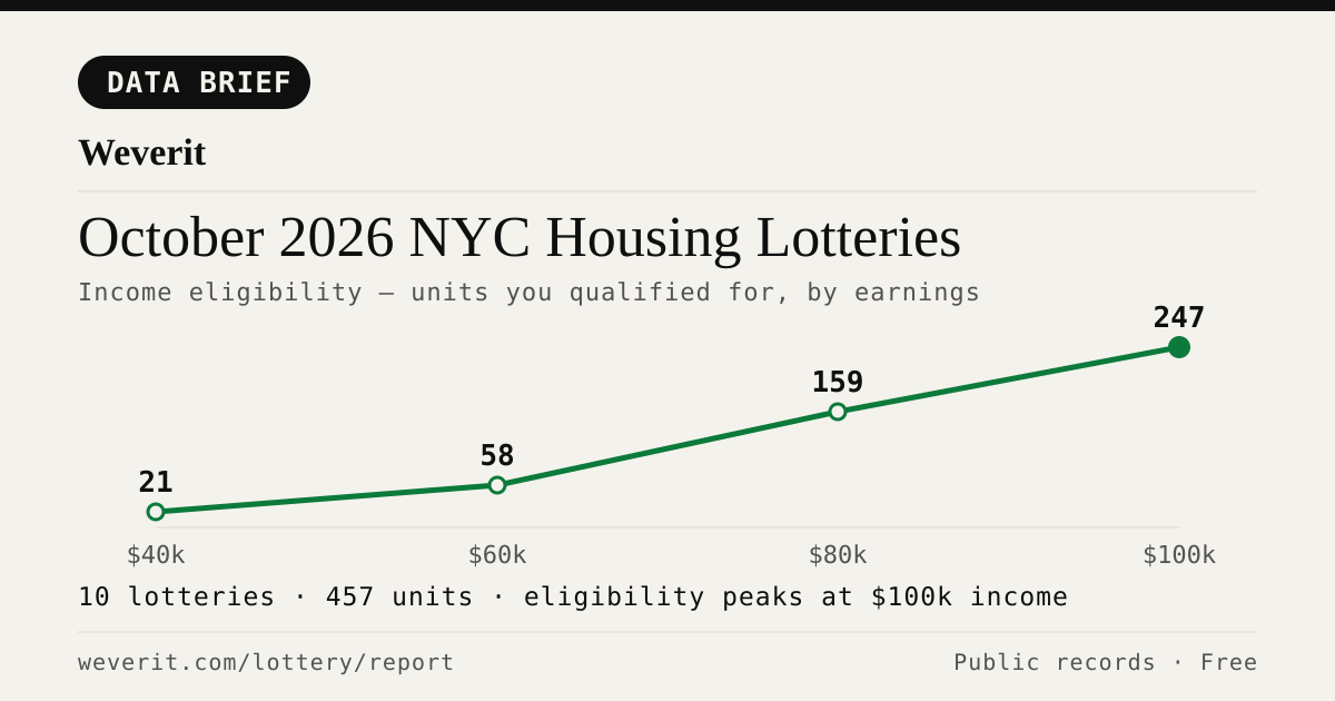
Income-eligibility curve for October 2026 NYC housing lotteries
DATA BRIEF·Nov 1, 2026

October 2026 NYC Housing Lotteries: Who Qualifies

11 lotteries, 477 affordable units — who qualifies by income, plus rents, AMI bands and application windows, from public records.

Read article →
Weverit guide cover: How Long Does NYC Housing Connect Take? From Application to Keys
GUIDE·Oct 28, 2026

How Long Does NYC Housing Connect Take? From Application to Keys

The official guide says interviews come two to ten months after a deadline. A 2026 case study of one Bronx building shows what can happen after that, and why most applicants drop out.

Read article →
Weverit guide cover: Selected in NYC Housing Connect? What Happens Next and the Documents You Need
GUIDE·Oct 28, 2026

Selected in NYC Housing Connect? What Happens Next and the Documents You Need

Your Housing Connect log number came up. Here is what the eligibility review looks like, which documents to gather, and the response deadlines that knock out most applicants.

Read article →
Weverit guide cover: NYC Housing Connect Login Problems: Recover Your Account
GUIDE·Oct 15, 2026

NYC Housing Connect Login Problems: Recover Your Account

Locked out of NYC Housing Connect? Learn how to reset your password, recover your email access, avoid duplicate applications, and contact HPD.

Read article →
Times Square in Manhattan, with digital billboards above the street and people looking up at the towers
HOUSING LOTTERY·Sep 27, 2026

Your Housing Connect Log Number Came Up. Here's What to Check Before You Sign.

A Housing Connect listing tells you the rent and the apartment size. It does not tell you how the building is run. Seven public records to check before you sign — and what a clean record does not mean.

Read article →
New york
MARKET-BRIEF·Sep 19, 2026

NYC's Smallest Apartment Buildings Have Four Times More Dangerous Violations Per Apartment Than Its Largest

We measured open HPD violations per apartment across NYC buildings. Buildings with six units or fewer carry four times the immediately-hazardous violations per apartment that buildings of 38+ units do — and they are the least likely to draw attention.

Read article →
Corner apartment building with fire escapes above storefront awnings and sidewalk seating
TENANT GUIDE·Sep 6, 2026

Pets in your NYC apartment: the no-pet clause, the three-month rule, and what your landlord can actually enforce

NYC's three-month pet rule may protect tenants in some buildings. Learn about landlord notice, court deadlines, exceptions, and how to document your case.

Read article →

Check another building

Pull the same public-records report for any NYC address — free, no signup.

Never miss an affordable apartment

Weverit's lottery digest tracks new NYC Housing Connect lotteries and no-lottery re-rentals — one curated email.

Get the lottery digest →
Report built September 27, 2026 · Click ↻ to refresh data · Public records: NYC Open Data, MTA, JustFix WoW; neighborhood amenities © OpenStreetMap contributors (ODbL)